Port of Ulsan
Land Use Plan
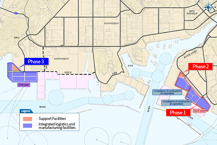
Floor plan for the development of Ulsan New Port Hinterland
Plan for Land Use
Phase 1 of the Land Use Planning on the Port Hinterland
※ Swipe the table
| facility | Area(㎡) | Proportion(%) | Note | ||
|---|---|---|---|---|---|
| Total | 423,457 | 100.00 | |||
| Type 1 Port Hinterland | 1.Integrated logistics and manufacturing facilities | 336,980 | 79.58 | ||
| 2.Work and convenience facilities | - | - | |||
| 3.Public facilities | Roads | 71,095 | 16.79 | ||
| Green belt | 15,382 | 3.63 | |||
| Other public facilities | - | - | |||
| Total | 86,477 | 20.42 | |||
Phase 2 of the Land Use Planning on the Port Hinterland
※ Swipe the table
| facility | Area(㎡) | Proportion(%) | Note | ||
|---|---|---|---|---|---|
| Total | 255,817 | 100.00 | |||
| Type 1 Port Hinterland | 1.Integrated logistics and manufacturing facilities | 194,146 | 75.89 | ||
| 2.Work and convenience facilities | 24,045 | 9.4 | |||
| 3.Public facilities | Roads | 31,329 | 12.25 | ||
| Green belt | 6,297 | 2.46 | |||
| Other public facilities | - | - | |||
| Total | 37,626 | 14.71 | |||
Phase 3 of the Land Use Planning on the Port Hinterland
※ Swipe the table
| facility | Area(㎡) | Proportion(%) | Note | ||
|---|---|---|---|---|---|
| Total | 598,345 | 100.00 | |||
| Type 1 Port Hinterland | 1.Integrated logistics and manufacturing facilities | 403,545 | 67.44 | ||
| 2.Work and convenience facilities | 46,482 | 7.77 | |||
| 3.Public facilities | Roads | 128,510 | 21.48 | ||
| Green belt | 19,808 | 3.31 | |||
| Other public facilities | - | - | |||
| Total | 148,318 | 24.79 | |||